🥾 ActiveLong weekend · from Savannah, GA

Cumberland Island Backpack, Marsh Kayak & Fort Pulaski

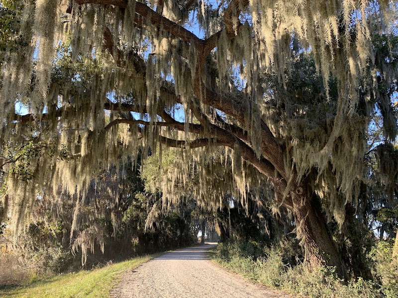
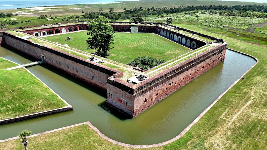
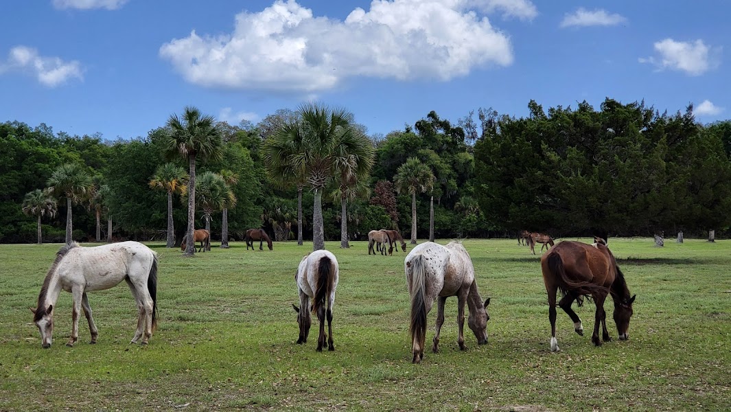
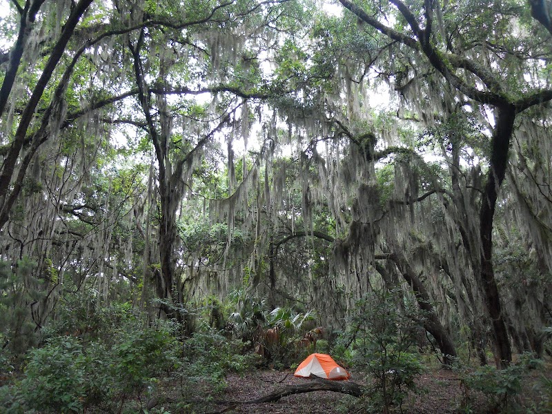
Three active days using Georgia's coastal wilderness — a backpacking overnight on Cumberland Island National Seashore on days one and two, and a combination of Savannah National Wildlife Refuge kayaking and Fort Pulaski National Monument on day three. Cumberland Island's backcountry campgrounds (Hickory Hill, Yankee Paradise, Brickhill Bluff) are accessible only on foot, 4-7 miles from the ferry dock; overnight campers have the island largely to themselves after the day-trippers depart on the afternoon ferry. The island at night is extraordinary: no artificial light, acoustic isolation, and the wild horse bands drifting through the campsite perimeter. Fort Pulaski NM on the return day is a Union Civil War engineering landmark — a brick masonry fort that was rendered obsolete in a single 30-hour bombardment in April 1862 when Union rifled artillery (newly developed) penetrated its walls, ending the age of masonry fortification in American military history.

Day 1 — Cumberland Island: ferry to Sea Camp, Dungeness Ruins, North Cut beach, Hickory Hill backcountry campDay 2 — Cumberland Island north: Plum Orchard Carnegie mansion (exterior), Grand Avenue marsh, ferry return, overnight St. MarysDay 3 — Savannah NWR kayak, Fort Pulaski NM (1862 Civil War rifled artillery test), return to Savannah
Day 1Cumberland Island — Sea Camp to Hickory Hill

Day 1Cumberland Island — Sea Camp to Hickory Hill

🚗 1 hr 20 min driving📍 4 stops
🌅
Morning
🚗
Drive
Savannah, GASt. Marys, GA — Cumberland Island Ferry
1 hr 20 min8:00 AM9:20 AM
Cumberland Island — Sea Camp Landing & Dungeness
4.7
The ferry landing at Sea Camp — the main visitor arrival point on Cumberland Island — followed by the 2.2-mile trail to the Dungeness ruins (Thomas Carnegie's 1884 59-room mansion, burned 1959). Wild horses graze around the mansion ruins and on the beach directly behind it; the Dungeness is the most visited point on the island. The Sea Camp beach connects to the island's south end and the Dungeness ruins via a short beach walk.
🍽️
Lunch
Cumberland Island Beach Walk — North toward Hickory Hill
4.8
A 4-mile north beach walk from the Dungeness south end toward the Hickory Hill backcountry camp — the Atlantic beach at mid-island is the widest and most remote section, backed by sand dunes and live oak hammock rather than any structures. Loggerhead sea turtle nest markers (May-August) and nesting shorebird areas are present along the beach; bottlenose dolphins work the surf line.
☀️
Afternoon
Hickory Hill Backcountry Campground
3.4
Hickory Hill backcountry campground — 4.3 miles from the ferry dock in the island's maritime forest, one of five backcountry sites on Cumberland Island. The campsite has a composting toilet and a water spigot (potable); no fires are permitted. The wild horse bands (100-200 horses on the island, descended from Carnegie-era horses) frequently pass through the campsite at night. No generators, no electric lights; the night sky over Cumberland Island is among the darkest on the East Coast.
🌙
Evening
Hickory Hill Camp — Night
4.9
Backcountry camping at Hickory Hill — NPS-managed site requiring advance reservation through recreation.gov. The campsite accommodates up to 4 parties; self-contained water and food required. The horse bands, raccoons, and armadillos that inhabit the island are the evening company. This is the only situation in the continental United States where wild horses walk freely through a designated federal campsite.
Day 2Cumberland Island North — St. Marys Return

Day 2Cumberland Island North — St. Marys Return

📍 4 stops
🌅
Morning
Plum Orchard — Carnegie Mansion Exterior
4.7
A 6-mile north trail walk from Hickory Hill to Plum Orchard — Thomas Carnegie's second mansion on the island, built in 1898 and donated to the NPS in 1972. Plum Orchard is intact (unlike the burned Dungeness) and is occasionally open for interior tours on the second Sunday of each month. The trail to Plum Orchard traverses the Grand Avenue — a 10-mile unpaved road running the length of the island through maritime forest, historically the main Carnegie estate road. The Plum Orchard exterior is freely accessible; the surrounding formal gardens are maintained by NPS.
🍽️
Lunch
Cumberland Island — Return South via Beach
4.7
The return walk south from Plum Orchard to Sea Camp — either via the Grand Avenue interior trail or along the Atlantic beach. The beach option provides the full ocean-facing coast perspective; the interior option traverses the live oak hammock with its feral horses, armadillo territory, and wild turkeys. The Sea Camp dock is 4.3 miles from Plum Orchard; the afternoon ferry departs at 2:45pm or 4:45pm (seasonal schedule).
☀️
Afternoon
St. Marys — Riverfront Historic District
4.7
St. Marys' Orange Street and waterfront historic district — a colonial-era port town with 19th-century residential and commercial buildings, the Cumberland Island National Seashore Visitor Center (with exhibits on the island's history and ecology), and the waterfront restaurants serving local Georgia coast seafood.
🌙
Evening
Riverview Hotel — St. Marys
4.3
The Riverview Hotel (1916) on the St. Marys waterfront — a National Register inn directly on the Cumberland Sound, one block from the Cumberland Island ferry dock. The hotel's restaurant serves dinner; the waterfront veranda overlooks the sound and Cumberland Island in the distance.
Day 3Savannah NWR — Fort Pulaski NM

Day 3Savannah NWR — Fort Pulaski NM

🚗 2 hr 10 min driving📍 2 stops
🌅
Morning
🚗
Drive
St. Marys, GASavannah National Wildlife Refuge
1 hr 20 min8:00 AM9:20 AM
Savannah NWR — Laurel Hill Wildlife Drive
4.6
The Savannah NWR Laurel Hill Wildlife Drive — a 4-mile auto and paddling route through freshwater impoundments and salt marsh. The impoundments were built as rice cultivation paddies in the 18th and 19th centuries; the dikes now serve as walking and biking trails with consistent alligator and wading bird sightings. A kayak launch at the drive entrance allows paddling of the same channels by water.
🍽️
Lunch
🚗
Drive
Savannah NWRFort Pulaski National Monument
20 min10:20 AM10:40 AM
Fort Pulaski National Monument
4.8
Fort Pulaski NM on Cockspur Island at the Savannah River mouth — a masonry brick fort (completed 1847, designed by Robert E. Lee as his first engineering post) that was rendered obsolete in 30 hours on April 11-12, 1862 by Union rifled artillery fire from Tybee Island, 1 mile away. The new Parrott rifles penetrated 7-foot-thick masonry walls that had been thought impregnable; the event ended the age of masonry fortification in modern warfare. The breach in the fort wall, still visible, is the most tangible example in the country of 19th-century weapons technology ending a centuries-old defensive tradition.
🌙
Evening
🚗
Drive
Fort Pulaski NMSavannah, GA
30 min5:00 PM5:30 PM
Plan your own escapeExplore more trips →