🥾 ActiveLong weekend · from St. Louis, MO
Elephant Rocks, Johnson's Shut-Ins & Current River
Three days south into the St. Francois Mountains — Missouri's oldest geology and the Ozarks' most dramatic scenery. Elephant Rocks' 1.5-billion-year-old pink granite boulders and Johnson's Shut-Ins' river-carved granite gorge fill day one. Day two reaches the Current River's springs and the largest single-outlet spring in the United States at Big Spring. Day three returns through Alley Spring's old mill and Meramec Caverns before arriving back in St. Louis.
Day 1 — Elephant Rocks SP (ancient pink granite), Johnson's Shut-Ins (granite swimming gorge), Taum Sauk Mountain (highest in MO), overnight IrontonDay 2 — Big Spring (840 million gal/day, largest in US), Current River float, overnight Van BurenDay 3 — Alley Spring & Mill (1894 roller mill), Meramec Caverns (Jesse James cave), return St. Louis
Day 1 — St. Francois Mountains, MO
Day 1 — St. Francois Mountains, MO
🚗 2 hr 45 min driving📍 4 stops
🌅
Morning
🚗
Drive
St. Louis, MO → Elephant Rocks State Park — Graniteville, MO
2 hr8:00 AM → 10:00 AM
Elephant Rocks State Park
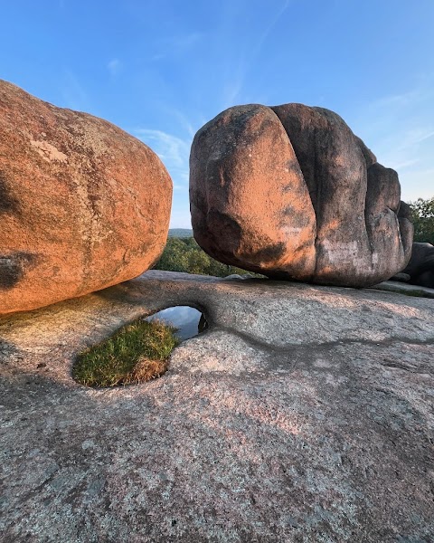
★ 4.9A collection of enormous pink and red granite boulders — the exposed tops of a pluton formed 1.5 billion years ago and now weathered into rounded elephant-like shapes, the largest weighing 680 tons and standing 27 feet tall. The Braille Trail (1-mile paved loop, the only fully accessible trail at a Missouri state park) winds between and beneath the boulders; the 'Elephant Train' formation lines up a series of especially large boulders in a row. Missouri's oldest exposed rock — forming when what is now the Midwest was a volcanically active ancient seabed.
10:00 AM📍 See location
🍽️
Lunch
🚗
Drive
Elephant Rocks SP → Johnson's Shut-Ins State Park
20 min11:00 AM → 11:20 AM
Johnson's Shut-Ins State Park
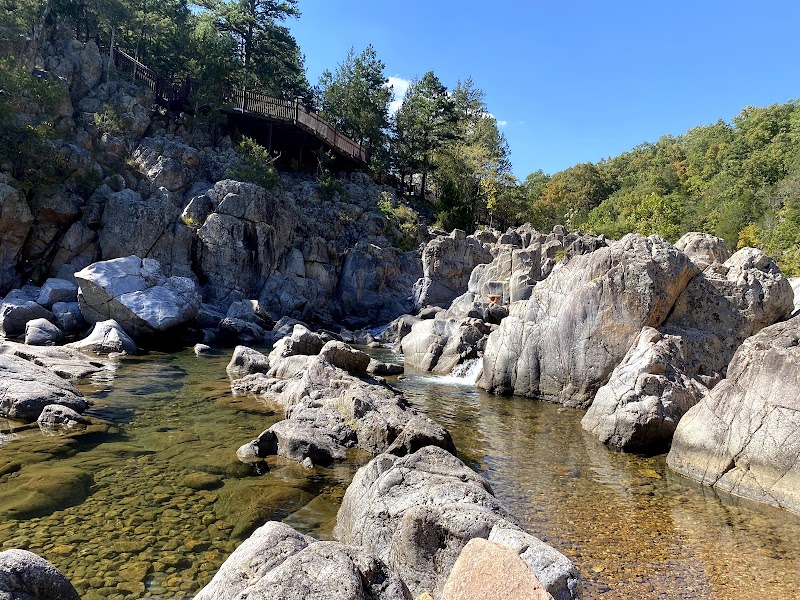
★ 4.8The Black River flows through a narrow rhyolite gorge here, creating a series of 'shut-ins' — rocky chutes, potholes, and pools where the river is 'shut in' by the igneous rock. The result is Missouri's best natural swimming hole: smooth granite and rhyolite slides, plunge pools, and whitewater channels accessible from a flat 0.5-mile trail from the parking area. After the Taum Sauk reservoir collapse in 2005 damaged the park, restoration revealed cleaner exposures of the 1.47-billion-year-old rhyolite. The water temperature holds around 68°F year-round from spring inflow.
11:20 AM📍 See location
☀️
Afternoon
🚗
Drive
Johnson's Shut-Ins SP → Taum Sauk Mountain State Park
25 min12:20 PM → 12:45 PM
Taum Sauk Mountain & Mina Sauk Falls
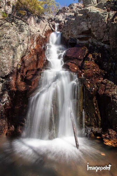
★ 4.8The highest point in Missouri — Taum Sauk Mountain at 1,772 feet, reached by a 0.3-mile walk from the parking area. The summit is forested with no dramatic viewpoint, but the 3-mile Mina Sauk Falls Trail from the trailhead descends to Mina Sauk Falls — the highest waterfall in Missouri, a 132-foot plunge over a rhyolite ledge into a pool below, accessible via a loop that passes through the St. Francois Mountains Wilderness.
12:45 PM📍 See location
🌙
Evening
Budget Host Inn — Ironton, MO
★ 2.5A basic motel in Ironton — the closest town to Taum Sauk and Johnson's Shut-Ins with hotel options. Ironton is a small Iron County seat with a few restaurants; the Courtney Motor Inn and similar properties are the main lodging options. Tomorrow's drive to Current River and Big Spring is 45 minutes south.
5:00 PM📍 See location
Day 2 — Ozark National Scenic Riverways — Current River
Day 2 — Ozark National Scenic Riverways — Current River
🚗 45 min driving📍 4 stops
🌅
Morning
🚗
Drive
Ironton, MO → Big Spring — Ozark National Scenic Riverways
45 min8:00 AM → 8:45 AM
Big Spring — Ozark National Scenic Riverways
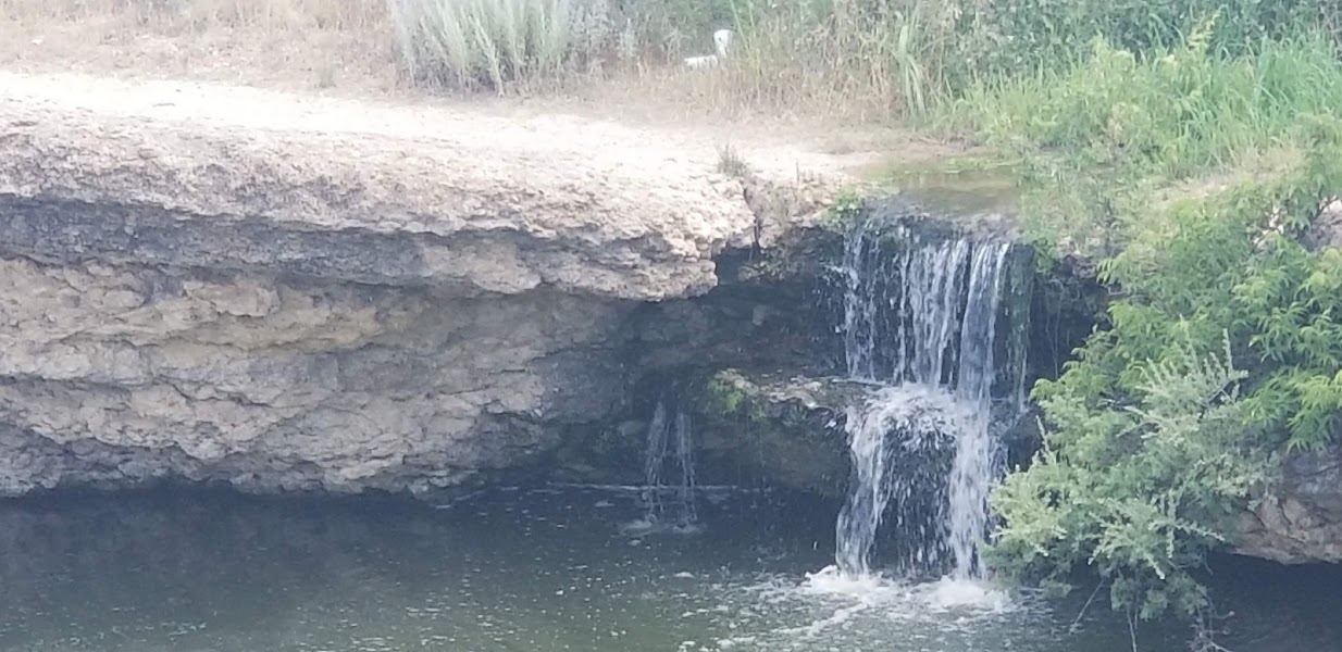
The largest single-outlet spring in the United States — Big Spring discharges 840 million gallons of 58°F water daily from a single opening at the base of a dolomite bluff, pouring directly into the Current River in a turquoise blue surge visible from the viewing platform 50 yards away. The spring pool is gin-clear to 30 feet deep; the color shift where spring water meets river water is dramatic. A 1-mile trail loops through the spring area and the Ozark riverfront; the 1930s CCC-built cabins and dining lodge operate as overnight and dining facilities.
8:45 AM📍 See location
🍽️
Lunch
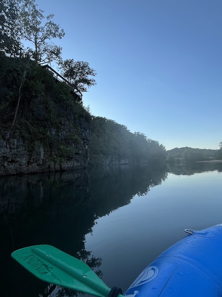
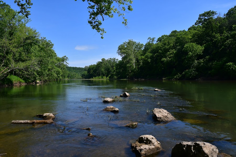
Current River Float — Akers to Pulltite
★ 4.4The Current River is one of the clearest rivers in Missouri — spring-fed to maintain 58-68°F year-round and protected within the Ozark National Scenic Riverways, the first national riverway designation in the US (1964). Canoe and kayak rentals are available at Akers Ferry from Current River Canoe Rental; the 11-mile float from Akers to Pulltite Campground passes Welch Spring (a large cave spring that feeds into the river at a clifftop bluff) and several gravel bars perfect for swimming. Allow 4-5 hours for a relaxed pace with stops.
9:45 AM📍 See location
☀️
Afternoon
📍
Pulltite Spring & Ozark Trail Segment
★ 4.6Pulltite Spring emerges from a bluff at the Pulltite Campground — a smaller spring (6 million gallons/day) feeding into the Current River with the same brilliant clarity as Big Spring. The Ozark Trail's riverways section passes through here, and a 2-mile segment along the river from Pulltite north to Round Spring makes an easy afternoon walk through shortleaf pine and mixed hardwood before driving to Van Buren.
12:00 PM📍 See location
🌙
Evening
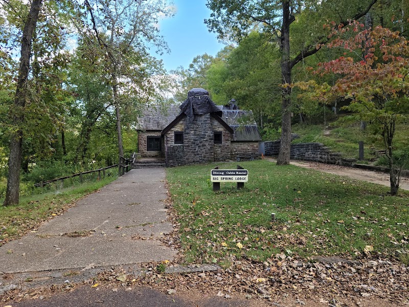
Big Spring Dining Lodge & CCC Cabins — Van Buren, MO
★ 4.2The 1930s CCC-built stone cabins at Big Spring — overnight lodging operated within the national scenic riverways, with the spring itself a short walk from the cabin area. Alternatively, the Best Western in Van Buren (3 miles away) is the main motel option. Tomorrow's drive north to Alley Spring and Meramec is 45 minutes west.
5:00 PM📍 See location
Day 3 — Alley Spring, Meramec Caverns — Return to St. Louis
Day 3 — Alley Spring, Meramec Caverns — Return to St. Louis
🚗 3 hr 15 min driving📍 3 stops
🌅
Morning
🚗
Drive
Van Buren / Big Spring, MO → Alley Spring & Mill — Jacks Fork River, MO
45 min8:00 AM → 8:45 AM
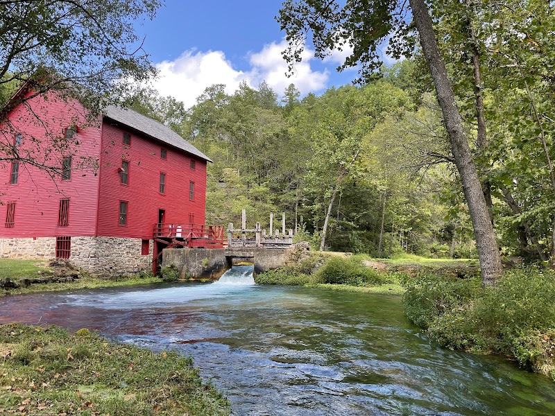
Alley Spring & Miller — Jacks Fork
★ 4.9One of the most photographed scenes in the Missouri Ozarks — the 1894 red grist mill standing beside Alley Spring, a turquoise-blue pool discharging 81 million gallons daily into the Jacks Fork River. The mill is a 2.5-story octagonal structure with a water wheel still in place; it operated until 1918 grinding corn and wheat for the surrounding hollow farms. The spring's blue-green color comes from dissolved minerals in the limestone aquifer; the clarity is such that individual stones on the spring bottom are visible through 30 feet of water.
8:45 AM📍 See location
🍽️
Lunch
🚗
Drive
Alley Spring, MO → Meramec Caverns — Stanton, MO
1 hr 30 min9:45 AM → 11:15 AM
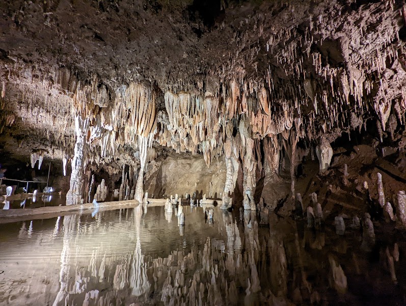
Meramec Caverns
★ 4.6A 4.6-mile commercial cave on the Meramec River — Missouri's longest cave open to tours, with a 1-mile guided walk through chambers including the 'Wine Table' (a flat-topped flowstone formation 60 feet wide and 20 feet tall), the 'Throne Room,' and formations unique in scale to this section of the Ozark karst. Meramec has been commercially operated since 1935; Jesse James reputedly used the cave as a hideout in the 1870s (possibly true — the cave was remote and undiscovered by most authorities). The cave maintains a constant 60°F.
11:15 AM📍 See location
☀️
Afternoon
Meramec State Park — River Trail
★ 4.7Adjacent to the caverns, Meramec State Park has 12 miles of river frontage on the Meramec River with a sand and gravel beach, swimming access, and several short trail loops through the floodplain forest. The Wilderness Trail (4.8 miles) connects to three additional caves on park property, including Fisher Cave (periodic guided tours). A relaxed final afternoon stop before the 60-minute drive back to St. Louis.
12:15 PM📍 See location
🌙
Evening
🚗
Drive
Meramec State Park / Stanton, MO → St. Louis, MO
1 hr5:00 PM → 6:00 PM
Plan your own escapeExplore more trips →